RCSP research projects
Reef Catchment Science Partnership (RCSP) projects target critical gaps in knowledge for the delivery of science for catchment management.
Join us as an Honours student or Research Higher Degree candidate for the opportunity to collaborate with researchers, policy makers and groups on projects to drive change, improve agricultural practices, protect catchment and ecosystem resilience, and improve water quality for the Great Barrier Reef (GBR).
Browse the list of available research projects below, and check your eligibility for the Michael St John Warne Memorial Scholarship.
Email rcsp.info@uq.edu.au to find out more, or to propose a project to address an important knowledge gap.
Predicting water quality
Can you predict the concentrations of one nutrient species using the known concentrations of other nutrient species?
The Queensland Government has been collecting nutrient concentrations in South-East Queensland (SEQ) and Great Barrier Reef (GBR) catchments for almost 2 decades, and in that time has amassed approximately 400,000 datapoints. With such large datasets, we are now in a position to develop statistical relationships between the concentrations of all the water quality parameters. Such relationships can be used to set up Quality Assurance/Quality Control rules for current and future sampling programs.
Furthermore, the logistics of sampling and analysing those samples is a major expense for the Queensland Government, and the Great Barrier Reef Catchment Loads Monitoring Program (GBRCLMP) and SEQ Catchment Loads Monitoring Program are always looking for avenues to reduce cost or provide justification for the reduction or simplification of sampling programs.
This project will suit a student with an interest in building statistical models of environmental datasets.
A machine learning approach to estimating dissolved inorganic nitrogen discharge from ungauged catchments
Catchment water quality models simulate large scale environmental processes with sufficient complexity to provide fit for purpose explanatory power. There are 2 categories of model development that limit model precision and reliability, one is limitations in knowledge that result in a misspecified model and the other is the quality and quantity of the observation data available to calibrate and test the model. This project aims to address both of these issues to some extent.
Given the costs and practical challenges associated with collecting observational data suitable for informing model calibration and validation, there are gaps in the water quality data available for model calibration. In the Great Barrier Reef catchment water quality modelling program, more than 30% of the total catchment area draining to the Great Barrier Reef lies outside of an area referenced by a water quality monitoring site.
This project will use available water quality monitoring data and catchment water quality models to investigate the potential for machine learning modelling methods to adequately estimate dissolved inorganic nitrogen (DIN) loads being generated and transported from the catchment landscape into the stream network.
Calculating loads discharged from an estuary
The Great Barrier Reef Catchment Loads Monitoring Program (GBRCLMP) provides essential data which is used to track trends and to calibrate catchment scale models linking land management practices and water quality. Catchment load is calculated as the product of discharge and concentration. At sites where there is tidal influence, volume can be computed from the discharge, or a freshwater discharge can be derived from de-tiding the discharge.
However, no adjustments are currently made to concentrations of sediment during a flood tide, which anecdotally, may accumulate above the sampling point to later be remobilised in larger events. When resuspension isn’t accounted for, and concentrations are applied to either a de-tided discharge or a volume, it would assume a seaward flux of analytes, which would bias the resultant load.
This project would collate evidence for movement of constituents back and forth due to tidal influence at GBRCLMP monitoring sites and investigate options for accounting for this influence when calculating loads. The work would contribute to improving confidence in the loads calculations that are foundational to tracking progress for the Reef 2050 Water Quality Improvement Plan.
Can the annual dissipation of pesticides at the GBRCLMP sites be described mathematically?
The Queensland Government has been collecting pesticide concentrations in South-East Queensland (SEQ) and Great Barrier Reef (GBR) catchments since 2009. Pesticide runoff at the beginning of the wet season generally results in dramatic increases in pesticide concentrations in receiving waters. These concentrations subsequently reduce, presumably because the amount of pesticide available for run off reduces as the wet season progresses. This results in a pattern of pesticide dissipation that is repeated each year. The pattern is most evident in the high-risk catchments (see figure below).
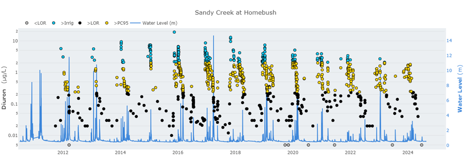
Each site potentially has its own dissipation pattern and raises the question: can you describe the site-specific dissipation of pesticides using a mathematical function, and is this pattern common to different pesticides?
This project will suit a student with an interest in building mathematical models of environmental datasets.
Fingerprinting water: Using real-time spectra to predict the concentrations of pesticides
This project will explore options to value add to real time data currently being collected by TriOS OPUS probes deployed for the Great Barrier Reef Catchment Loads Monitoring Program. The probes provide nitrate and total suspended solid (TSS) equivalent data. But there is potential to derive greater value from the probes. The potential to use the real time TSS data calculate sediment loads, rather than the traditional approach of using grab samples, would be investigated.
There is also potential to use the spectra generated by TriOS OPUS probes to predict concentrations of pesticides (e.g., atrazine, diuron, with nitrate, phosphate and imidacloprid previously analysed by another honours project in 2023, the thesis is available and this research can be built on or new approaches can be used) in rivers that discharge to the Great Barrier Reef. Establishing such relationships could enable real-time water quality monitoring of waterways for a greater number of water quality parameters and would enable quicker and cheaper methods of monitoring waterways within the Great Barrier Reef catchments.
Predicting the required sample coverage for a flood event
The Great Barrier Reef Catchment Loads Monitoring Program (GBRCLMP) monitors water quality during ambient conditions as well as during events. Events, or periods of increased flow, account for a significant portion of annual transport of contaminants.
The GBRCLMP directs significant resources to ensuring that events are well sampled. Calculation of an event load requires samples to be captured across the rising, peak and falling stages of the hydrograph. To ensure that a load can be calculated, more samples are collected than analysed. Once the event has passed, analysis of the hydrograph determines which samples will be analysed. The effort to oversample, review and then discard extra samples is considerable. Contaminant loads for an event are a function of catchment characteristics (size of the catchment, topography, geology and soil types and catchment landuse) as well as event specific characteristics (rainfall intensity and distribution, groundcover and land management practices).
This project aims to analyse monitoring data from the GBRCLMP to determine whether catchment characteristics are the primary driver of event characteristics and therefore could be predicted based on knowledge of site behaviour. The work can potentially reduce the costs associated with oversampling while ensuring the GBRCLMP continues to provide robust sampling for loads calculation.
Analysing monitoring data to inform management
Unpacking dissolved inorganic nitrogen to ensure targeted management of Great Barrier Reef catchment water quality
The water quality in the Great Barrier Reef (GBR) catchment waterways is impacted by elevated nitrate and ammonium loads, known and reported as dissolved inorganic nitrogen (DIN), primarily due to agricultural activities. Studies have shown that DIN concentrations are particularly high in areas with intensive agriculture, such as sugarcane and banana plantations, where fertiliser application often exceeds plant requirements. This excess DIN is transported into waterways, especially during wet season conditions, increasing loads in the GBR catchment that can affect the reef's health.
However, the nitrate-to-ammonium concentration ratios in these waterways are influenced by various factors, some of which are independent of each other, including land use practices, hydrological changes, and the instream nutrient process. Effective nutrient management strategies are crucial to mitigate these impacts. Understanding the nitrate-to-ammonium concentration ratios will give greater insight into improving the GBR lagoon's water quality.
Statistical analysis of temporal trends in nutrient and sediment concentrations and loads
The Great Barrier Reef Catchment Loads Monitoring Program (GBRCLMP) has been collecting pesticide concentration data between 2009 and 2021 and nutrient concentration data since 2006. To date, temporal trends have been estimated using very complex source catchment models. But with so much monitoring data it is possible to use this data to determine whether concentrations have changed over time.
To date, analysis for changes in concentration over time (temporal trend analysis) has only been conducted for pesticides. Despite significant investments targeted at reducing sediment and nitrogen in runoff from agriculture, no trend analyses have been conducted using the monitoring data. This project will determine whether the efforts/investments of the Australian and Queensland governments to improve land management practices and hence water quality have been successful.
Understanding groundwater in the Burdekin
Groundwater rising in the lower Burdekin is a significant environmental issue with potential to negatively impact agriculture in this highly productive area. Further, excessive use of groundwater for irrigation in the Burdekin delta leaves the area vulnerable to salt water intrusion (SWI). SWI has the potential to render this resource unusable for agricultural purposes and also to shift the biogeochemical processes that drive release and bioavailability of nutrients from soils.
Understanding of the water quality in Burdekin groundwater, compared to local surface waters, is key to designing management strategies to address the risks. This study would review available monitoring data from groundwater bores in the region to identify spatial and temporal trends and compare to the surface waters. The analysis would include assessment of indicators of the presence and extent of SWI. Drawing on existing data, this work aims to further understanding of the complexities driving groundwater quality and provide insights that could direct future decision making.
Can we discern trends in the annual Pesticide Risk Metric data published by the Great Barrier Reef Marine Park Authority Monitoring Program?
Taucare et al. (2022) published a trend analysis of the photosystem II (PSII) herbicide concentration data published by the Great Barrier Reef Marine Park Authority Monitoring Program (MMP). That study described statistically significant increases in some PSII herbicides at some MMP sites.
More recently, the 2022 Scientific Consensus Statement (Negri et al. 2024) has called for an analysis of the trends in MMP data using the Pesticide Risk Metric. The Pesticide Risk Metric includes risk from 22 pesticides, including two insecticides, nine PSII herbicides and ten other herbicides, including metolachlor and MCPA – the herbicides that dominated pesticide risk at several MMP sites (see figure below).
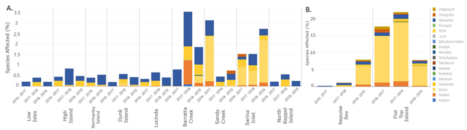
This project could specifically include a trend analysis for metolachlor. This project would require the calculation of pesticide risk metrics for MMP datasets available back to 2005 and the application of statistical tests. This project will suit a student interested in building statistical models of environmental datasets.
What factors dictate the magnitude of the Pesticide Risk in GBR catchments?
Different catchments in the Great Barrier Reef catchment area are characterised by different pesticide risks. For example, within the Mackay Whitsunday NRM region, several catchments generally experience very high risk from pesticides whereas other catchments experience very low risk (see Pesticide Risk Metric dashboard).
A recent analysis in the 2022 Scientific Consensus Statement (Negri et al. 2024) suggested that the proportion of land use dedicated to sugarcane and horticulture, and river discharge (see figure below) explained the differences, but this has yet to be examined in detail.
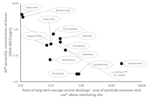
This project will suit a student interested in building statistical models of environmental datasets.
Human dimensions of water quality improvement
Agricultural producers’ perceptions of practice change in Reef catchments
The Queensland Department of Environment, Science and Innovation collects behavioural and social data from agricultural producers in Reef catchments to inform project and program design to enhance practice adoption and water quality outcomes.
This project will conduct the statistical analysis of temporal and spatial trends in the perceptions of practices to improve water quality and explore linkages to observed trends in water quality.
Does real time data influence farm management decision making?
Real time water quality data has the potential to provide valuable feedback to growers on the environmental implications of different management practice decisions. TriOS OPUS probes, currently provide real-time measurements on nitrate-nitrogen and total suspended solids at sites across the Great Barrier Reef Catchment.
This project would work with landholders to investigate the potential for feedback from real time monitoring to influence the decisions that they make for fertiliser and irrigation management actions on their farm.
Economics of water quality improvement
How much will it cost to restore Queensland’s rivers?
River restoration is a primary means of reaching important water quality goals for the Great Barrier Reef and Southeast Queensland, offsetting increased water quality pollution due to population growth, and contributing to a wide range of emerging global nature repairs targets.
However, there is an urgent need for estimates of river restoration cost to be updated to reflect more recent market conditions and variation in cost due to different river characteristics across Queensland. More robust cost data could enable scaling up of investment in river restoration to progress toward a range of social goals.
This project will compile recent river restoration cost data from a range of locations across Queensland to determine average river restoration costs, as well as river characteristics that influence deviations from this average.
Miscellaneous
Analysis and write up of the 2+ years of orbitrap data collected by the GBRCLMP, including a statistical analysis of land use relationships
The Queensland Department of Environment and Science has conducted non-targeted organic chemical analysis of rivers that discharge to the GBR for two years. This project will collate that data to determine what chemicals are present, how frequently each is detected, summary concentration statistics and determine if there are relationships between their occurrence and land use.
This project will help determine what chemicals are included in future chemical analysis of GBR waterways.