New research has revealed unique mountain formation and higher-than-expected risk of catastrophic earthquakes in Türkiye.
The study was conducted by The University of Queensland’s Honorary Associate Professor Tonguç Uysal, Professor Jian-xin Zhao and their former visiting PhD student Dr Tunahan Aykut from Istanbul Technical University in Turkey (currently a postdoctoral researcher at the University of Pau in the Adour Region in France).
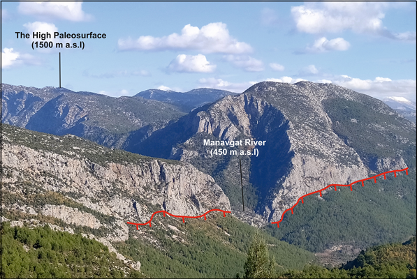
Using UQ’s novel geological dating techniques, they found the first direct evidence that the Central Taurides – mountains in the southern Anatolia region – have risen around 1.5 kilometres in just 450,000 years.
“This rate of growth is 50 per cent faster than Mt Everest's current growth rate,” Dr Aykut said.
“And it seems to be because plate tectonics in this region work uniquely and differently from other places.
“Previous studies, based on common geophysical techniques, have suggested that mantle upwelling can cause surface uplift.
“We hypothesise that this process could be the mechanism for the growth of the Central Taurus Mountains, but more studies are needed to determine what specifically makes this region different.”
The research has also revealed that the region may not be as safe as once thought.
“South-central Turkey has long been considered one of the country’s safest areas seismically,” Dr Aykut said.
“But this study reveals it’s actually active - not with frequent quakes, but with rare, catastrophic ones that carry major risk.
“Some of these fault zones are active only every 1,000 years or longer, but have a much larger impact than more common, smaller ones.
“Therefore, this region must be monitored in terms of seismic hazard, and because this region is unique, studies must be conducted that could serve as an example for other places around the world.”
The research used cutting-edge dating techniques at UQ’s Radiogenic Isotope Facility, helping decode the timing of catastrophic earthquakes and uplift.
“During fault generation, carbonate rocks – limestone – dissolve, allowing new carbonate minerals – calcite – to precipitate on fault surfaces,”
“These minerals contain uranium, which allows us to track the history of these events.
“Dating old rocks – older than a few million years – is done using various radiometric techniques, however, radiometric dating of young minerals has remained difficult.
“UQ’s Radiogenic Isotope Facility now has ‘U-series dating’ facilities, only available in certain places around the world, allowing us to conduct such cutting-edge research.”
The research is published in Nature Communications.
The project was a collaboration between UQ, Istanbul Technical University and Stockholm University.


